18.20.230 TOD (Transit Oriented Development)
Purpose: The Transit-Oriented Development District is a planned district that encourages a mix of residential, commercial, and employment opportunities within identified bus rapid transit (BRT) corridors, commuter rail stations, or other high-capacity transit areas. This district encourages a mix of residential, commercial, and employment opportunities within transit corridors or areas served by transit. This development pattern promotes transit ridership, ensures access to transit, and limits conflicts between vehicles, pedestrians and transit operations. The technique allows for a more intense and efficient use of land at increased densities for the mutual reinforcement of public investments and private development. Uses and development are regulated to create a more intense built-up environment, oriented to pedestrians, to provide a density and intensity that is transit supportive. This section encourages a safe and pleasant pedestrian environment near transit stations by allowing intensive areas of shops and activities, providing for amenities (such as benches, kiosks, and outdoor cafes), and limiting conflicts between vehicles and pedestrians. The TOD technique is restricted to areas within one-half (½) mile of a transit facility. This area is equivalent to a ten (10) minute walking distance.
Because most transit users will walk only one-quarter (¼) to one-half (½) of a mile to a transit facility, transit influence areas require high densities on small areas of land. The City finds that uses inconsistent with transit will undermine the most efficient use of limited land areas within a TOD, and may render the transit system unworkable. Accordingly, the uses permitted within a TOD are those that are dependent upon, or which may generate, a relatively high level of transit use. Uses that would interfere with transit use and which generate few transit trips are not permitted within a TOD. Further, the City finds and determines that minimum levels of density as set forth in this section are required to support transit ridership, and that lower levels of density will not support transit ridership and will create unacceptable levels of vehicular congestion.
This district is consistent with the Transit-Oriented Development (TOD) Centers future land use category, Gateway District, and Regional and Local Transit Corridors. It also implements the following policies of the Comprehensive Plan:
•LUCC-3.1: Encourage Housing near Services. Encourage higher-density housing development near transit services.
•LUCC-3.2: Link between Transportation and Land Use. Implement land use plans and programs that support effective transit, an efficient street system, and alternative transportation modes.
•LUCC-5.2: Connections to Centers. Encourage pedestrian, bicycle, and transit connections to and within commercial centers.
•OT-3.2: Housing. Add high density, multifamily housing within and adjacent to the downtown area that will help support desired uses and amenities. Provide housing to serve a diverse population, including affordable housing, senior housing, special needs housing, and transit-oriented development.
•HN-1.2: Mixed Uses and Mixed Incomes.
•HN-2.2: Complete Neighborhoods. Encourage a “complete” neighborhood concept for new development which includes a variety of residential densities on appropriately sized parcels, opportunities for shopping, nearby support services and conveniently sited public facilities, including roads, transit, and pedestrian connections, parks, libraries and schools.
•HN-2.3: Higher Residential Densities. Target future medium- and high-density residential development to locations that are accessible to and integrated with potential employment and transit centers.
•HN-2.1, HN-2.5, HN-4.1, and HN-4.2: Provide a full range of housing choices, affordable housing, and neighborhoods that enable residents to “age in place.”
•Principle HN-5: Encourage housing densities and styles that will support vibrant retail and transit centers.
•HN-5.1: Mixed-Use Neighborhoods. Utilize zoning and development designations that encourage and enable a mix of residential, retail and commercial space in areas that are close to public transportation and planned transit nodes and corridors.
•HN-5.2: Provide for higher-density residential housing along major existing and planned public transit corridors.
•M-2.5: Transportation Corridors and Transit Nodes. Encourage growth along existing and planned transportation corridors and transit nodes.
A. Applicability
1. Rezoning to a TOD is subject to the procedures for the PD district (Section 18.20.220) and this section. The following areas are eligible for rezoning to a TOD district:
a. Property located within a Transit-Oriented Development (TOD) Center future land use category or a Regional or Local Transit Corridor in the Comprehensive Plan; and
b. Property located within one-half (½) mile of a transit station or major bus boarding location.
2. Transit Influence Area
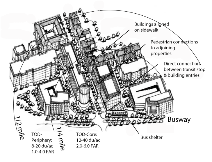
a. The TOD includes a transit influence area with two (2) distinct subareas known as the “TOD Core” (TOD-C) and the “TOD Periphery” (TOD-P), defined below:
|
Core |
All areas within one-quarter (¼) mile of a busway or transit station. |
|---|---|
|
Periphery |
All areas between one-quarter (¼) mile and one-half (½) mile from a busway or transit station. |
b. A TOD rezoning application must include:
(1) If not adjacent to another TOD district, at least one TOD-Core area adjacent to a busway or a transit station. No TOD-Periphery is required.
(2) If adjacent to a TOD district described in subsection A.2.b(1), above, at least one TOD-Core area.
(3) If adjacent to a TOD district with a TOD-Core and within an eligible location for a TOD-Periphery, the application may include a TOD-Core, TOD-Core and TOD-Periphery, or a TOD-Periphery only.
B. Uses and Density
1. Permitted Uses
The uses permitted in a TOD must be established in the development agreement approved with the TOD rezoning. Those uses are generally those permitted in the R-4, N, C-1, C-2, C-3 and O districts.
2. Prohibited Uses
The following uses are not permitted in a TOD:
|
LBCS Code(s) |
|
|---|---|
|
Function 2110 |
Automobile sales or service establishment |
|
Function 2120 |
Heavy consumer goods sales or service |
|
Structure 2110 |
Office building with drive-through facility |
|
Structure 2210 |
Shop or store building with drive-through facility |
|
Structure 2250 |
Warehouse discount store building |
|
Structure 2270 |
Gasoline station |
|
Structure 2280 |
Automobile repair and service structures |
|
Structure 2593 |
Car care center |
|
Structures 2620-2636 |
Heavy industrial structures and facilities and oil refineries |
|
Structures 2700-2782 |
Warehouse or storage facility |
C. Densities and Intensities
The requested densities, in terms of number of units per gross residential acre and total number of dwelling units, must be set forth in the development agreement. The development agreement must comply with Table 18.20.230-2, below.
|
(A) Location/Size |
(B) Minimum Density |
(C) Maximum Density |
(D) Minimum FAR |
(E) Maximum FAR |
|---|---|---|---|---|
|
Core |
||||
|
Less than 2 acres |
16 |
40 |
2.5 |
6 |
|
2 acres or more |
12 |
36 |
2 |
4 |
|
Periphery |
||||
|
Less than 2 acres |
12 |
20 |
1.5 |
4 |
|
2 acres or more |
8 |
16 |
1 |
2 |
Rules of interpretation for Table 18.20.230-2: The applicable land use categories are set forth in Column (A). The density for the particular use must be at least the amount set forth in Column (B) for residential uses, and must not exceed the amount shown in Column (C). The floor area ratio (FAR) for the particular use must be at least the amount set forth in Column (D) and must not exceed the amount shown in Column (E).
D. Lot and Site Design
1. Site Design
Site design must incorporate the Category 3 site design standards in the TOD-Core, and Category 3 or 5 site design standards in the TOD-Periphery.
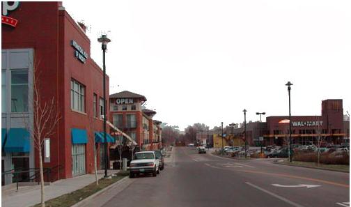
Figure 1. Building and site design at the TOD-Periphery is more flexible in order to accommodate supportive uses
2. Front Setback
The front setback must be established as follows, measured from the edge of the sidewalk:
|
Category |
Minimum Front Setback (feet) |
Maximum Front Setback (feet) |
|---|---|---|
|
Single-Family Dwelling Units |
10 |
25 |
|
Multiple-Family Dwelling Units and all other Dwelling Units |
0 |
15 |
|
0 |
5 |
|
|
Industrial or Civic Buildings |
0 |
30 |
3. Transit Orientation
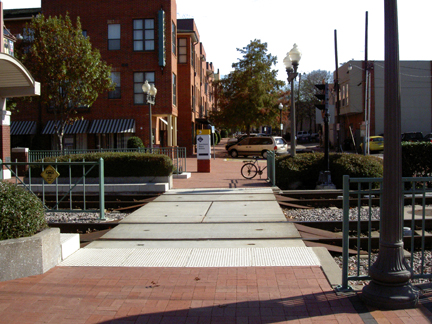
All sites must orient their interior and on-site circulation to the closest adjacent bus shelter or transit station.
4. Pedestrian Access
New retail, office and institutional buildings within the Core subarea must provide for convenient pedestrian access to transit through the measures listed below:
a. Pedestrian connections to adjoining properties must be provided except where such a connection is impracticable due to unique topography.
b. Pedestrian connections must connect the on-site circulation system to existing or proposed streets, walkways, and driveways that abut the property. Where adjacent properties are undeveloped, streets, accessways and walkways on site must be aligned or stubbed to allow for extension to the adjoining property.
c. A direct pedestrian connection must be provided between the transit stop and building entrances on the site.
E. Building Design
1. Generally
Building design must conform to Chapter 18.15, Building Design Standards.
2. Commercial Buildings
Commercial buildings may designate the entire building area above the ground floor or the second floor for residential use.
F. Parking
1. Parking Supply
a. The minimum parking requirements must within the Core and Periphery subareas be as follows:
|
Area |
Minimum Parking Spaces (see Parking and Loading Standards, Section 18.30.160) |
Maximum Parking Spaces |
|---|---|---|
|
Core, within 500 feet of a transit station or bus shelter |
None |
75% of the required parking spaces |
|
Core, balance of area |
50% of the required parking spaces |
100% of the required parking spaces |
|
Periphery |
75% of the required parking spaces |
120% of the required parking spaces |
b. Existing development may redevelop existing parking areas for transit-oriented uses, including residential uses, commercial uses, offices, bus stops and pullouts, bus shelters, and park-and-ride stations.
c. All other provisions of the parking standards apply to a Transit-Oriented Development.
2. Parking Structures
Parking structures must have retail or residential uses along the first-floor building area that abuts a sidewalk.
G. Parks and Open Space
The parks/open space/civic space standards (Section 18.30.170) do not apply to a Transit-Oriented Development.
H. Landscaping and Screening
1. The following standards do not apply to a TOD (see Section 18.30.130):
b. Parking lot interior landscaping requirements for any parking area that is located in a rear yard or interior to a block.
2. All other requirements of Section 18.30.130 apply to a TOD.
3. In order to provide a continuous pedestrian transition for residential neighborhoods and commercial areas, retail, service, or civic land uses must not be separated from multifamily or single-family land uses within the TOD by berms or buffers unless a trail or sidewalk is established that provides a direct connection between the uses.
I. Streets
1. Adequate Public Facilities Exemption
A TOD is not subject to the adequate public facilities standards requirements for road networks (see Section 18.30.040).
2. Street Design
Public and private streets must conform to the community design standards (see Section 18.30.220).
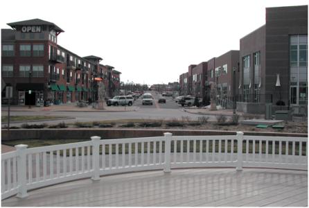
Figure 5. Buildings aligned to street within a convenient walk to transit station
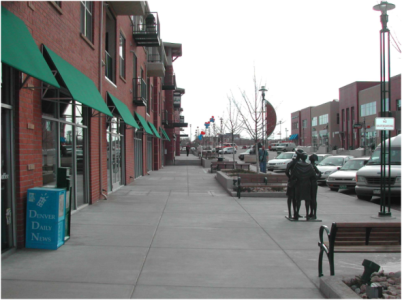
Figure 6. Development in TOD uses community design street standards with sidewalks and on-street parking
(Ord. 19-64 § 16, 2019)